 Catálogo de datos del IEO
Keyword
Cetacean abundance
27 record(s)
Type of resources
Categories
Topics
INSPIRE themes
Keywords
Contact for the resource
Provided by
Years
Formats
Status
-
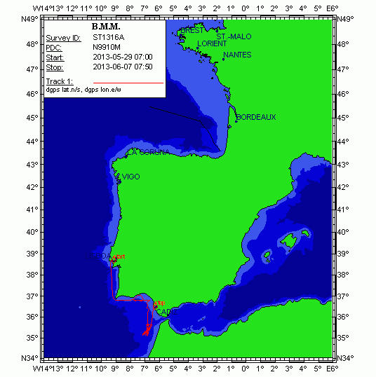
The northern "Contourite Depositional System" located within the Gulf of Cadiz is well studied and was drilled last year during IODP expedition 339. We aim to acquire 3 additional seismic lines over these drill sites towards the shallow shelf for sequence stratigraphic studies and acquire a connection profile to the southern part of the Gulf, along the Moroccan margin. The research along the Moroccan margin builds upon previous investigations (R/V Belgica 2002, 2005, 2008) and will focus on smaller current-related deposits in order to fully understand the hydro- and sediment dynamic picture of this area during the past 2.4 Ma. This will allow to better assess the evolution of cold-water coral ecosystems. This will be achieved by gathering additional seismic lines and perform hydrographic measurements. In the second half of June, several cores will be gathered from the southern part of the Gulf of Cadiz with the R/V Marion Dufresne. In order to visualize the subsurface of these core sites, 6 seismic profiles will be gathered, connecting these core sites.
-
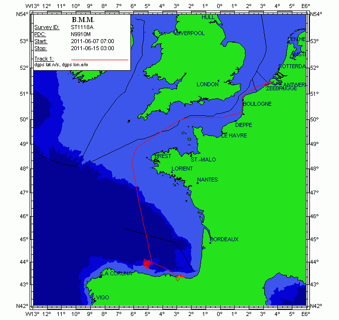
This cruise aims to investigate the seismic stratigraphy and palaeoceanographic evolution of the Le Danois contourite depositional system (Van Rooij et al., 2010), at several locations in the Le Danois "intraslope basin". Previous research (R/V Belgica in 2004, among others) has highlighted a significant correlation with the Cadiz CDS, suggesting a nearly simultaneous control by the Mediterranean Outflow Water since the Early Pliocene. As such, the Le Danois CDS is the only location in the Bay of Biscay where high-resolution climate change (e.g. bottom currents) may be recorded in a continuous way. It will assist in better constrain the role of the MOW in the thermohaline circulation system. Therefore, this large-scale sediment body is an ideal target for (a) investigating the MOW palaeoceanography within the NE Atlantic basin and (b) a palaeoclimatologic reconstruction of the Cantabrian margin. The main objective of this campaign is to acquire additional geophysical data which will give more insight in the construction and 3D evolution of this sedimentary deposit. This campaign will be executed in close cooperation with the Proyecto Coordinado CONTOURIBER (CTM 2008-06399-C04/MAR), with invited researchers from Spanish research institutes. More specifically, R/V Belgica ST1118a aims to perform: 1.High-resolution single channel sparker seismic profiling: investigation of the stratigraphic framework and the sedimentary environment in the western part of the intraslope basin between the Vizco High (west), the Lastras canyon system (east), Le Danois bank (north) and the Asturias slope (south). This will mainly focus on the lateral and temporal evolution of Le Danois drift and the Gijon drift and their interaction. The location of these profiles is determined based on industrial multichannel airgun profiles, in order to compare seismic methods with different penetration depths and seismic resolutions. We are very grateful to TGS-NOPEC for allowing us to use a large unpublished data set of seismic records from the Cantabrian Sea. 2.Hydrography: at specific sites in the intraslope basin, CTD casts will aim to better map the presence and behavior of the Mediterranean Outflow Water within the main elements of the Gijon and Le Danois drifts. The newly acquired Seapoint turbidity sensor will be able to indicate regions of active sediment transport within the Le Danois CDS. Multibeam bathymetry with the Belgica EM1002 will be only be used as a backup in case of spare time or failure of the other methods. The proponents are aware of the Marine Protected Area status of the Le Danois Bank, and will be vigilant to respect the guidelines of conducting scientific research. In order to ensure vigilance with respect to marine mammals, a team of whale watchers of MUMM, ULg (Belgium), CRMM (France) and OCEAMM (France) will be participating. This part of the campaign is a cooperation between the RCMG (UGent), the University of Vigo, the Geological Survey of Spain (IGME), the Spanish Oceanographic Institute (IEO), the Spanish Institute of Marine Sciences (CMIMA-CSIC) and the University of Cádiz.
-

- Estimate the abundance of cetaceans in oceanic and shelf waters of the European Atlantic in 2016. - These estimates will give the necessary information to evaluate the good environmentla status and the conservation status of the main species of cetaceans in the Atlantic. - In addition these estimates are needed to evaluate the impact of the different anthropogenic pressures on the populations of these species.
-
Main targets of PECAN are: - Setting-up of R/V Ángeles Alvariño as acoustic-fisheries prospecting vessel. - Optimizing sampling design for the systematic study and abundance estimating of Canary Islands pelagic species. - Using echo integration as a method to estimate Canary Islands pelagic species abundance.
-
Cetaceans, Oceanography and biodiversity of the Deep Waters of El Hierro y La Palma islands
-
Conducting systematic sampling contemplated within the research project IEO oceanographic time series data in the Gulf of Cadiz.
-
i. To estimate of the force of recruitment by means of ecointegration of the populations of Sardine and anchovy located on the Atlantic coast of Portugal and southern of Galicia. ii. Oceanographic characterization on the area to prospect. iii. Study the distribution of apical predators in the area to prospect.
-

To estimate the spawning stock biomass of european anchovy (Engraulis encrasicolus) in the Bay of Biscay in spring.
-
To estimate the spawning stock biomass of european anchovy (Engraulis encrasicolus) in the Bay of Biscay in spring.
-
The campaign targets under INCOECO 1012, to carry on board the research vessel Angeles Alvariño, are the identification and mapping of habitats and characterization of biogenic benthic and demersal species. Specific objectives focus on the investigation of benthic Bank area of La Concepción by direct and visual methods. Specifically: · Intensive videogrammetry HD visual and sampling with ROV Liropus 2000 · Extensive visual videogrammetry HD with sled towed "APHIA 2012". · Study epibenthic fauna through the use of beam trawl, to capture sessile and reduced mobility fauna in shallow soft bottoms and rock, and rock dredge for qualitative sampling of wildlife sessile hard bottom fauna. · Study of the endobenthic fauna by use of the meso mud dredge box-corer. · Recognition with multibeam bathymetric and TOPAS parametric probe.